I activated Pilot Knob (W6/SD-435) back on 11 October.. It's a lowly one-point peak near where the California, Arizona, and Mexican borders meet. I described a bit about the mountain
here.
Some great information on accessing the peak is in this
PDF document.
Getting there: As described on pages 66-68 of the above PDF document.
On a previous activation attempt, I tried to climb using the more direct route along edge of the quarry on the north side of the mountain, but I lost the trail and I ran out of time due to other commitments later in the day. I decided to instead make an attempt climbing the western slope of the mountain, attempting to use the loop trail described in the book, except I would do an out-and-back hike instead of a loop in order to shorten the hike. I entered the location of the trail head into my Garmin and went there.
 |
| Overexposed pic of trailhead. Lat/Long: N32 44.065" W114 45.450, looking east. Sun was rising, hence the overexposure. |
At that location I noticed two trails: One of the left/north, and one of the right/south. Given that I was going to do the out-and-back route, I selected the left trail and started climbing. The climb was steep but the well-defined trail made the route simpler, until I reached the crest of the first ridgeline. Here the trail disappeared. I ended up shifting to the left (north) a bit, and ultimately found a draw which led to a false summit. This false summit was at the far end of the east-west ridge which makes up crest of the mountain. From this spot the going was a bit easier, with numerous trails visible and with the summit in view.
 |
| The mountain was made of a mixture of sharp granite and a softer conglomerate (I think). The softer rock eroded away in places, leaving holes and small caves. Bats, which I had noticed on my first attempted climb, probably live in many of these small caves. |
 |
| This cairn was located at the false summit. My APRS capable handheld's packets were first picked up at this point. | |
 |
| The ridge from the location of the false summit, leading to the peak. Yuma, Arizona can be seen beyond the mountain. |
The hike on the ridge was a good bit easier. Less steep, and the ground was a firmer granite than the softer rock leading to the false summit.
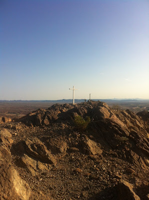 |
| Getting closer to the summit. A Gipfelkreuz!--although not as ornate as those in the Old World. |
 |
| The Summit Cross was made of wood, and appears to be installed into the foundation of the old KIVA television transmitting tower. | | |
|
|
Having reached the summit, I quickly deployed my end-fed wire antenna and commenced making contacts using the FT-817ND and the VX-8DR. Propagation was actually not too bad, given the conditions.
Even with conditions only so-so, I commenced making numerous contacts throughout the US, using both SSB and CW. I also attempted contacts on 50, 144, and 222 MHz, but no takers. I did make contact with a ham in Yuma on 446.0 (K7ACS), who also ran an APRS digipeater that received my packets.
 |
| My Pilot Knob activation log on SOTAData. |
As for my spotting technique, I self-spotted using the web browser on my phone. I could have easily self-spotted using APRS, SMS, SOTA Goat, and likely the Reverse Beacon Network. AT&T cell signals were plentiful, and APRS coverage, once on the summit and out of the draws, was fine:
 |
| My APRS breadcrumbs from the false summit leading to the summit. |
 |
| At the false summit, by APRS packets were received by the BAJA digipeater, perhaps 50 miles away. I am N0PCL-7. |
|
 |
| At the summit, my APRS packets were received at the K7ACS digipeater. I worked K7ACS on 446.0 during the activation as well. |
|
 |
| The view into Mexico from the summit. The US-Mexican border is very visible. |
Having completed the activation, I started my hike down. Having more of
a bird's eye view while on the summit made route selection a bit
easier. I simply picked a prominent trail that headed west down the
mountain. Given how easy the descent was, I recommend that future
activators use the following coordinates as your trail head: N 32
44.050", W114 44.090". That will place you approximately one draw to
the north of the trailhead I used for this activation, and it will make
navigation to the summit much easier! Simply go to those coordinates
and hike up the well-defined and well-ducked trail.
A few other notes for a future activation:
- You are operating very close to the Mexican border. The place is crawling with Immigration and Customs Enforcement (ICE) officers. I recommend you carry identification on your person in order or alleviate suspicions that might ruin your activation attempt.
- It's a short hike, and not too strenuous, but I still recommend you bring a good amount of water. On the day I hiked this peak, it was in the mid-80s before the sun came up, and there's not much shade (no shade, actually).
Lastly, I promised a review of the WLB-817 battery pack that I had installed in my FT-817ND. The battery performed marvelously. Battery voltage barely dropped, even when transmitting a full 5 watts of power on CW during the five long "dahs" of the "0" in my callsign. I suspect that there's power for several more activations in a single battery charge. I'm very happy with this purchase.


No comments:
Post a Comment